
Heavy rainfall on Saturday caused the Bavali River to overflow, inundating the Palapuzha bridge near Iritty in Kannur. | K. MOHAN Heavy rain triggered widespread disruption across the hilly regions of Kannur district on Saturday (August 1, 2026), damaging roads, inundating houses, forcing evacuations, and prompting the authorities to impose travel and tourism restrictions.Eight families comprising 26 people were shifted to a relief camp after floodwaters entered houses at Peratta Thottipalam in Ulikkal grama panchayat. Fire and rescue services, assisted by residents, rescued those stranded in their homes and relocated 19 adults and seven children to the relief camp.Two persons were reported missing in separate rain-related incidents. Hanifa, 40, of Kottamchuram in Manthana village, was swept away in the Kunhirapuzha at Peravur. In another incident, Rajesh, a swimming instructor from Thiruvananthapuram, was swept away while trying to rescue a person who was stranded on a river island at Meenthulli in Pullingome village. A search is on for the two missing persons.Traffic ban imposedHeavy rain damaged Boys Town-Palchuram road, disrupting traffic between Kannur and Wayanad. The District Disaster Management Authority (DDMA) has imposed a night traffic ban on the route from 6 p.m. on Saturday to 6 a.m. on Sunday (August 2, 2026), owing to the risk of landslides.A woman, Sumathi, stranded on a river island at Thuruth in Pullingome-Kozhichal, was rescued by Fire and Rescue Services personnel and residents.Landslides and flash floods affected several parts of the district. Water submerged Mattara, Vattiyamthode and Vayathur bridges in Ulikkal panchayat, while the Aralam Butterfly Sanctuary was inundated. Rafting in the Kariyangode river was suspended due to strong currents.Following a sudden rise in water level the Kariyangode river, five families living on a river island in Kozhichal were shifted to relatives’ house as a precautionary measure.Pazhassi dam shutters raisedThe Pazhassi dam shutters were raised after the reservoir level went up following heavy rainfall in the catchment area. Residents living along the banks of the river have been advised to remain alert.The District Tourism Promotion Council temporarily closed tourist spots like waterfalls and parks attached to beaches, besides suspended rafting and kayaking activities. Vehicle entry to the Muzhappilangad beach has been banned, and the public has been advised to avoid visiting beaches owing to rough sea conditions.District Collector P. Vishnuraj chaired two meetings of the DDMA to review the evolving situation. Officials were directed to keep emergency shelters ready, strengthen preparedness in landslide-and flood-prone areas, issue warning to people living near rivers and the coast. Published - August 01, 2026 09:57 pm IST
An orange alert, warning of intense heavy rainfall, has also been issued for the districts of Thrissur, Palakkad and Ernakulam | Vibhu In the wake of heavy overnight rains triggered by a slow-moving, well-marked low-pressure system over central India, the India Meteorological Department (IMD) upgraded the rain alert for Kerala. A red alert has been issued for eight districts in Kerala, including Idukki, Kottayam, Pathanamthitta, Malappuram, Kozhikode, Wayanad, Kannur and Kasaragod, where extremely heavy rainfall is likely over the next 24 hours.Kerala heavy rains LIVE - August 1An orange alert, warning of intense heavy rainfall, has also been issued for the districts of Thrissur, Palakkad, and Ernakulam, while the remaining districts, Thiruvananthapuram, Kollam, and Alappuzha, have been placed under a yellow alert, where isolated heavy rainfall is expected.Meanwhile, extremely heavy and very heavy rain was reported across large parts of the State on Friday night (July 31), inundating vast stretches of low-lying areas. Laha in Pathanamthitta recorded the highest rainfall, receiving 236 mm of rain between 8:30 a.m. on Friday and 5:30 a.m. on Saturday. It was followed by Venkurinji in Pathanamthitta with 182.5 mm and Neriamangalam in Ernakulam with 171.5 mm.The shutters of the Aruvikkara and Neyyar dams were opened on Saturday following heavy inflow into the reservoirs’ catchment areas. People living in the vicinity of the dams and along the banks of the rivers have been advised to remain alert due to the rising water levels.As the water level in Neyyar Dam has crossed the third warning level due to heavy rains, 4 shutters of the dam were raised by 20 cm each (total 80 cm) at 7.30 a.m. on Saturday. Four shutters of Aruvikkara dam were raised by 40 cm each (total 200 cm including the 40 cm raised the previous day) at 6.30 am.Thiruvananthapuram District Collector Anu Kumari informed that those living in the vicinity of the dam and those living on both banks of the rivers should be vigilant. Published - August 01, 2026 10:58 am IST

For the August–September period as well, the IMD forecasted rainfall at below 94% of the long-period average, indicating a weaker-than-normal second half of the southwest monsoon. | The forecast also projects below-normal rainfall during the second half of the southwest monsoon season (August–September), although some parts of peninsular India, central, eastern, and northeastern India, and the northern parts of the northwest could receive normal to above-normal rainfall.The below-normal rainfall in August is likely in many parts of the country, except over much of eastern peninsular India, some parts of northwest and central India, and isolated areas of eastern and northeastern India, where normal to above-normal rainfall is possible. Maximum temperatures during the month are expected to remain above normal across most of the country, while minimum temperatures are likely to be normal to above normal across most regions.July rains near normalThe IMD also said moderate El Niño conditions over the equatorial Pacific are expected to strengthen through the remainder of the monsoon season, while neutral Indian Ocean Dipole (IOD) conditions are likely to persist before a positive IOD develops during September. The latter can help monsoon rains.For the August–September period as well, the IMD forecasted rainfall at below 94% of the long-period average, indicating a weaker-than-normal second half of the southwest monsoon.The outlook follows a near-normal July at the all-India level, despite forecasts issued earlier in the season that had anticipated subdued rainfall because of the developing El Niño. On June 30, the IMD had forecast a minimum 6% deficit in July rainfall but India has so far got 101% of the usual amount of rainfall. July is the rainiest of the four monsoon months and critical to agriculture. According to the IMD, while July’s rainfall helped erase much of the deficit that had built up during June, the distribution of rainfall remained uneven across regions.A long-term chart released by the IMD shows considerable year-to-year variability in August rainfall since 1901, with no strong long-term linear trend in departures from normal over the historical record. Published - July 31, 2026 09:55 pm IST
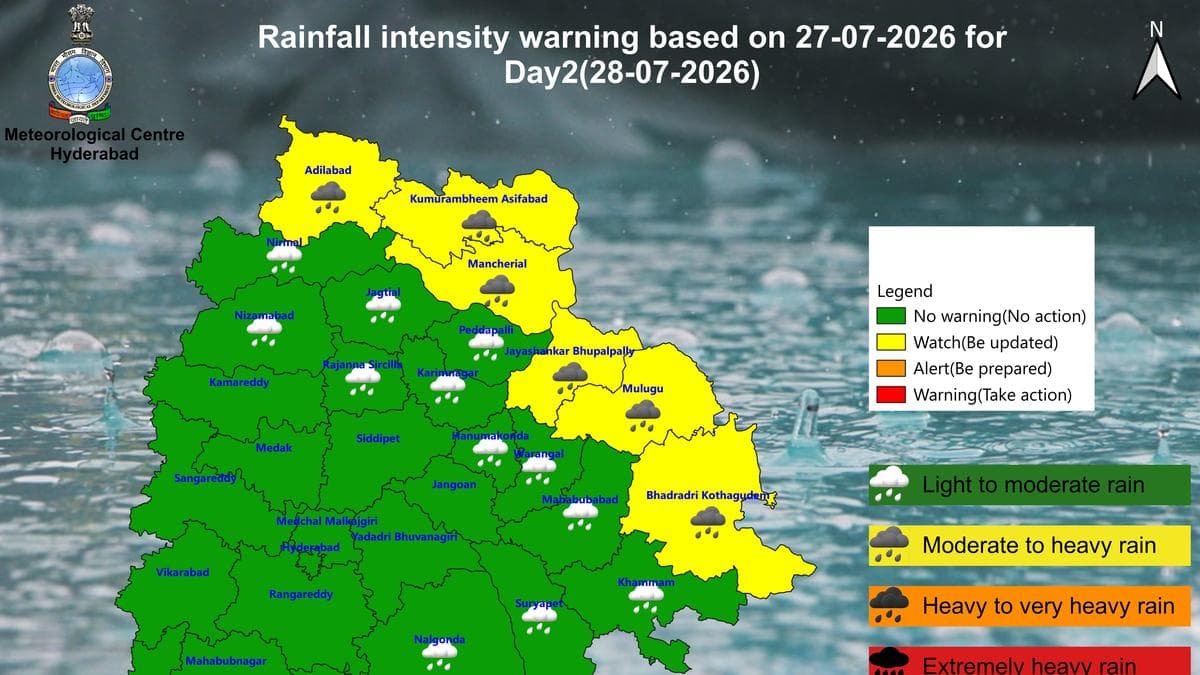
India Meteorological Department’s (IMD) forecast for Telangana districts for July 28, 2026 | According to IMDs latest bulletin, heavy rainfall is very likely to occur at isolated places in Adilabad, Kumaram Bheem Asifabad, Mancherial, Jayashankar Bhupalpally, Mulugu and Bhadradri Kothagudem districts. Additionally, strong surface winds are very likely to prevail at isolated places in all 33 districts of the State.Hyderabad weather forecastHyderabad city and its surrounding areas for the next 24 hours will see a generally cloudy sky. “Light to moderate rain or thundershowers are very likely to occur in parts of the city. The maximum and minimum temperatures are likely to be around 29℃ and 23℃ respectively,” the bulletin said. Published - July 27, 2026 04:22 pm IST

Discussion (0)